How to Find Us
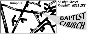 Finding the church can be a little tricky as we are lucky in Knaphill to be blessed with a cluster of Churches. Our church is about 150 yards from the shops amidst some houses, so can be easy to miss if you don’t know the area.
We are located just off the centre of the village of Knaphill, to the Northwest of Woking, in Surrey. To reach us, we suggest you use the map at the links here: Streetmap.co.uk or Google Maps (each open in a new window).
If driving from Knaphill you should look out for the small “Baptist Church” white sign opposite the church and the Bus Stop directly outside. If you reach the crossroads by the Garibaldi Pub you have missed us. If coming from the M3 side you will pass the Garibaldi Pub and if you reach the main village without seeing us you have overshot.
Parking
Parking is available on the High Street outside the Church, or for the fitter amongst you there are a couple of large free car parks signposted in the village (behind the Co-op, and off the Broadway). Please be considerate of our neighbours if you do park on the roadway and avoid blocking any driveways. The parking directly outside the church is a bustop during the week; on Sundays we keep this clear for dropping off and picking up our less able bodied members.
Local, but no car?
If you have difficulty getting to the church due to lack of transport and would like to visit us then contact us (see contact page) and we will do our best to arrange a lift for you.
|
Our street address is 88 High Street |
To plot a route to the church, please enter your postcode below: Your postcode: |
| ⇐ Back: Who is KBC? | Next: FAQs ⇒ |

